Marine Traffic Ship Positions Offline 2018
Ultimate and one of the largest merchant-ships' database. More then 300K ships in database!
Scanning public resources, collects many data for commercial fleet, such as:
- ship particulars;
- deck equipment;
- engine equipment;
- radio-communication equipment;
- crew;
- status;
- schedules;
- position;
- pictures
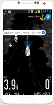
Marine Traffic Ship 2018 displays near real-time positions of ships and yachts worldwide.
Connected to the largest network of AIS receivers, the app covers most major ports and shipping routes.
• View VESSELS ON THE LIVE MAP, search for ships, boats and seaports and see what's near you!
• More than 100,000 VESSELS PER DAY report their positions via
Marine Traffic Ship 2018 AIS
• View live wind and 48-hour WIND FORECASTS on the map
• ANIMATED PLAYBACK of vessel's track
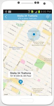
• PORT ARRIVALS & DEPARTURES live for over 4,000 ports and marinas, current conditions in ports and estimated time of arrival for the boats & ships.
• Browse 1,5 MILLION PHOTOS of ships, harbors and lighthouses
and much more!
➜ NEW! Identify vessels around you at a glance with the Augmented Reality tool (in-app purchase)
Just point your device's camera to the horizon and get all the information you need about the vessels in your area: name, flag, speed, distance from you and a lot more.
Also, for
Marine Traffic Ship 2018 paying subscribers:
• NAUTICAL CHARTS
• SAT-AIS DATA
Features:
* Nearly 80,000 ships online.
* Covering most ports on the world.
* Detail ship's information. In addition to AIS information, D.W.T/Gross ton/Build year is also provided.
* Powerfull ship/port search engine.
* Auto-refresh current region's ship data.
* Google satellite map is available.
* Port's weather forecasts all over the world.
* View 1000 NOAA Charts.
* Share ship's current position with your friends.
• View VESSELS ON THE LIVE MAP, search for ships, boats and seaports and see what's near you!
• More than 100,000 VESSELS PER DAY report their positions via
Marine Traffic Ship 2018 AIS
• View live wind and 48-hour WIND FORECASTS on the map
• ANIMATED PLAYBACK of vessel's track
• PORT ARRIVALS & DEPARTURES live for over 4,000 ports and marinas, current conditions in ports and estimated time of arrival for the boats & ships.
• Browse 1,5 MILLION PHOTOS of ships, harbors and lighthouses
and much more!
✔️ Every vessel type is marked in a specific color
✔️ You can explore plenty of different vessel types: Fish carriers, Crude Oil Tankers, Fishing Vessels, Other Tugs / Special Crafts, Bulk Carriers, Fire Fighting Vessels, Service Vessels, Passenger Ships, Training Ships, Yachts and much more
9Apps 4.9