


Hot applications make large number of downloads. 20,000+ users downloaded TopoNavigator latest version on 9Apps for free every week! It truly does not offer any money. This hot app was released on 2019-03-26. You can also find some other similar apps here.
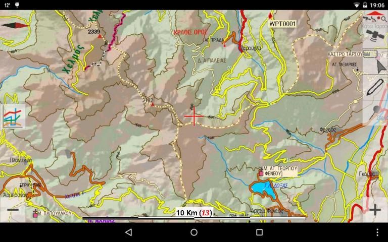
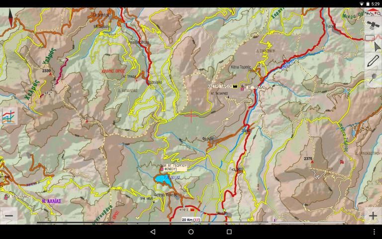
Turn your smartphone or tablet into a powerful navigation cartographic tool that will navigate you through inaccessible dirt roads & forgotten footpaths of Greece, with the accuracy of TopoNavigator maps.
New feature: become a beta tester and get early access to new features: https://play.google.com/apps/testing/anadigit.toponavigator.maps
The free version offers:
MAPS
• Offline map tiles downloading & caching (including Greek Cadastre aerial photos, OSM, Google & Bing Maps) on internal or external memory (micro SD card)
• Map downloading along 1 or more selected tracks or routes.
• Offline maps management page with the possibility to delete a specific map on a specific level
• Map Rotate, Tilt & Zoom with multitouch gestures
• Greek Geodetic Reference System (GGRS87) coordinates
• Auto or manual map scaling to improve map legibility on high-resolutions screens
• Speed-related map rotation auto-switch based either on compass or GPS heading
• Combined speed-related Auto-Zoom & Auto-Tilt (3D perspective view) with 3 profiles (Travel, Offroad, Extreme 4x4)
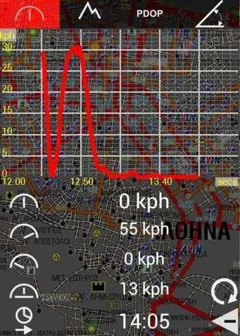
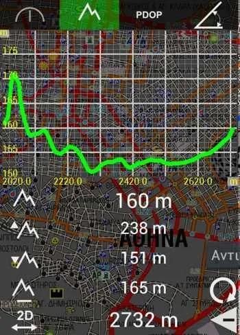
• Continuous Speed, Elevation, GPS Accuracy & Slope charts when a GPS is connected
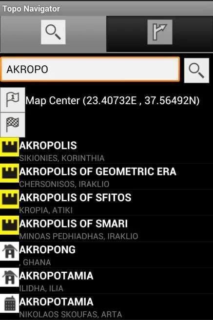
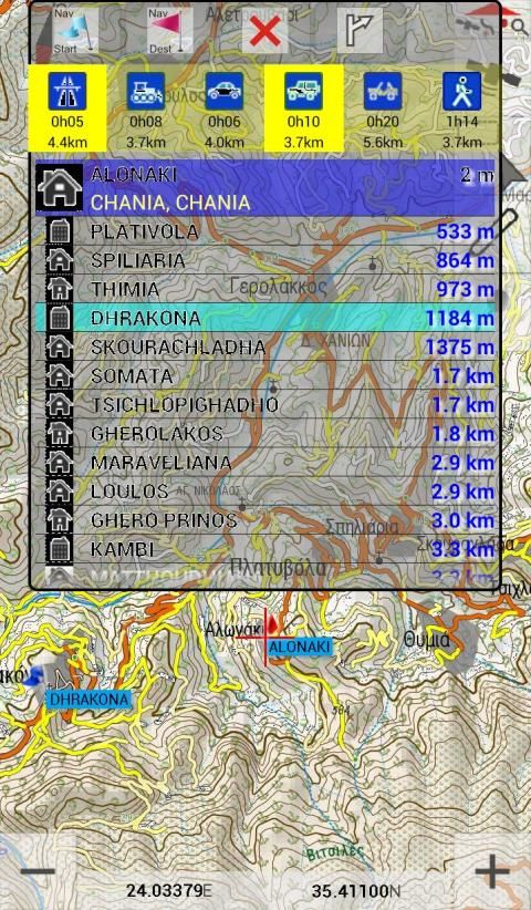
• Offline search for 200000 woldwide cities including 20000 nameplaces, 1900 archaelogical sites & 1400 monasteries in Greece
ROUTING
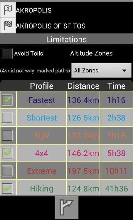
• Online routing for Greece. Options include fastest & shortest route, altitude zone, toll avoidance.
• Start & destination positions can be set either on map, GPS fix, using long press on map, search, coordinates or waypoints. Navigation points can be deleted or modified.
• Unlimited number of routes can be stored for offline use.
DATA
• Digitalization of lines and points with a finger, mouse or stylus.
• Edit lines on your device: click to add a vertex, drag a vertex to move it, long press on a vertex to create waypoint, delete it or split the line.
If 2 lines are selected, use the popup to join the 2 selected lines or delete them.
• Ability to set a solid symbol for lines or choose from 5 color palettes interpreting speed, slope, elevation, pace and accuracy Equal Intervals analysis.
• Unlimited waypoint capture on or off GPS fix. Create, edit or delete waypoint. Move points to GPS fix, to the map center or with drag & drop.
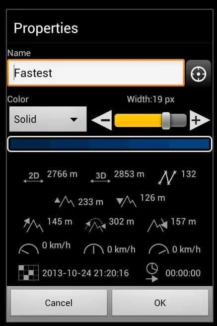
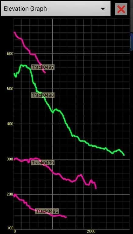
• Unlimited track recording with custom time & distance intervals. Recording line symbol uses a 4-color palette to display GPS accuracy. Track statistics include elevation & speed graphs, duration, min, max & avg speed, min & max elevation, total ascent & descent, 2D & 3D length
• Import & export waypoints & tracks on KML, KMZ & GPX formats.
• After exporting data, you can share the file with Dropbox, Google Drive, email...
• Simplify tracks on save. Options include: no generalization, mild (1m tolerance), moderate (3m) and strong (6m) generalization.
INTERFACE
• 4 languages (english, greek, french & german)
• Direct link to TopoNavigator GPS Info free app that gives satellite info, visualizes pitch & roll values, records NMEA sentences, sends position by SMS or e-mail & offers an advanced Trip Computer
The paid version (TopoNavigator Extreme, 40€ one-time purchase for 3 devices):
• gives access to TopoNavigator maps & offers 6 routing profiles (Fastest, Shortest, SUV, 4x4, Extreme 4x4 and Hiking).
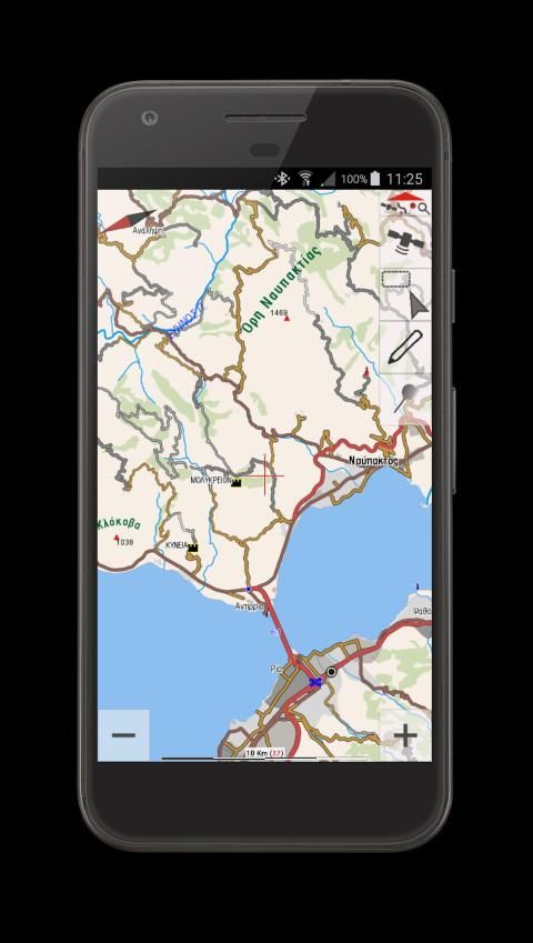
TopoNavigator maps are considered by many the best maps of Greece for any outdoor adventure activity (hiking, 4x4 driving, mountain bike) and includes 20m contour lines.
The maps are available in Greek & Latin characters and cover all regions of Greece: Athens and Attica, Central Greece, Peloponnese (Southern Greece), Epirus, Macedonia & Thrace (Northern Greece), Cyclades, Ionian, Dodecanese & Creta (Kriti) islands.
• Points & lines digitized on screen (off GPS fix) get elevation values from a high accuracy 30m cell Digital Elevation Model (currently DEM is server-based and only covers Greece).
To view TopoNavigator maps visit: http://www.topoguide.gr/index-map.php
Mengubah smartphone atau tablet menjadi menu alat kartografi yang kuat yang akan menavigasi Anda melalui diakses jalan tanah & setapak lupa Yunani, dengan akurasi peta TopoNavigator.
Fitur baru: menjadi tester beta dan mendapatkan akses awal untuk fitur baru: https://play.google.com/apps/testing/anadigit.toponavigator.maps
Versi gratis menawarkan:
MAPS
• Offline ubin peta men-download & caching (termasuk Yunani kadaster foto udara, OSM, Google & Bing Maps) pada memori internal atau eksternal (kartu micro SD)
• Peta download bersama 1 atau lebih yang dipilih trek atau rute.
• Offline peta halaman manajemen dengan kemungkinan untuk menghapus peta tertentu pada tingkat tertentu
• Peta Putar, Tilt & Zoom dengan gerakan multitouch
• Yunani Geodetic Reference System (GGRS87) koordinat
• Auto atau skala peta manual untuk meningkatkan peta keterbacaan on-resolusi tinggi layar
• Gratis terkait rotasi peta auto-switch didasarkan baik pada kompas atau GPS pos
• Gabungan terkait kecepatan Auto-Zoom & Auto-Tilt (perspektif 3D) dengan 3 profil (Travel, Offroad, Extreme 4x4)
• Kecepatan berkelanjutan, Elevation, GPS Akurasi & Slope grafik ketika GPS terhubung
• pencarian Offline untuk 200000 kota woldwide termasuk 20000 nameplaces, 1900 situs arkeologi & 1400 biara-biara di Yunani
RUTE
• online routing Yunani. Pilihan meliputi tercepat & terpendek rute, zona ketinggian, penghindaran tol.
• Mulai & tujuan posisi dapat diatur baik di peta, GPS fix, menggunakan tekan lama pada peta, pencarian, koordinat atau titik arah. poin navigasi dapat dihapus atau dimodifikasi.
• Unlimited jumlah rute dapat disimpan untuk penggunaan offline.
DATA
• Digitalisasi dari garis dan titik dengan jari, mouse atau stylus.
• Edit garis pada perangkat Anda: klik untuk menambahkan simpul, tarik simpul untuk memindahkannya, tekan lama pada titik untuk membuat waypoint, menghapus atau membagi garis.
Jika 2 baris yang dipilih, gunakan popup untuk bergabung dengan 2 baris yang dipilih atau menghapusnya.
• Kemampuan untuk mengatur simbol yang kuat untuk garis atau memilih dari 5 palet warna menafsirkan kecepatan, kemiringan, elevasi, kecepatan dan akurasi Equal analisis Interval.
• Terbatas waypoint capture atau mematikan GPS fix. Membuat, mengedit atau menghapus waypoint. Pindah poin untuk GPS fix, ke pusat peta atau dengan drag & drop.
• Terbatas track rekaman dengan waktu kustom & interval jarak. baris rekaman simbol menggunakan palet 4-warna untuk menampilkan akurasi GPS. Statistik lagu termasuk elevasi & kecepatan grafik, durasi, min, max & kecepatan rata-rata, min & max elevasi total pendakian & keturunan, 2D & 3D panjang
• Impor & ekspor waypoints & trek pada KML, KMZ & GPX format.
• Setelah mengekspor data, Anda dapat berbagi file dengan Dropbox, Google Drive, email ...
• Menyederhanakan trek save. Pilihan meliputi: tidak ada generalisasi, ringan (toleransi 1m), sedang (3m) dan kuat (6m) generalisasi.
INTERFACE
• 4 bahasa (Inggris, Yunani, Perancis & Jerman)
• Link langsung ke TopoNavigator GPS Info aplikasi gratis yang memberikan info satelit, visualisasi lapangan & roll nilai, mencatat kalimat NMEA, mengirimkan posisi melalui SMS atau e-mail & menawarkan perjalanan lanjutan Komputer
Versi dibayar (TopoNavigator Ekstrim, 40 € satu kali pembelian untuk 3 perangkat):
• memberikan akses ke peta TopoNavigator & menawarkan 6 profil routing (Tercepat, Terpendek, SUV, 4x4, Extreme 4x4 dan Hiking).
peta TopoNavigator dianggap oleh banyak artikel tentang Yunani untuk kegiatan petualangan outdoor (hiking, 4x4 mengemudi, sepeda gunung) dan termasuk garis kontur 20m.
Peta yang tersedia dalam karakter Yunani & Latin dan mencakup seluruh wilayah Yunani: Athena dan Attica, Central Greece, Peloponnese (Southern Yunani), Epirus, Makedonia & Thrace (Yunani Utara), Cyclades, Ionian, Dodecanese & Creta (Kriti) pulau .
• Tempat & garis digital pada layar (off GPS fix) mendapatkan nilai elevasi dari 30m sel akurasi tinggi Digital Elevation Model (DEM saat ini server berbasis dan hanya mencakup Yunani).
Untuk melihat peta TopoNavigator kunjungi: http://www.topoguide.gr/index-map.php
Version 4.0.7:
• A series of larger GPS fix symbol added
9Apps 4.9


