
Welcome to our app recommend. 30,000+ users downloaded GPS Polygon Area latest version on 9Apps for free every week! It is simply to learn how to use it. This hot app was released on 2018-07-21. To know more information, read the paragraph below.
The app consist from 2 parts:
• polygon GPS registrator
• area and perimeter calculator
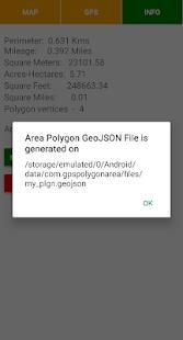
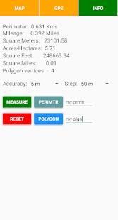
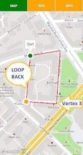
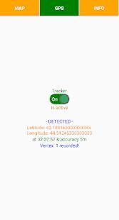
The registrator takes a polygon vertices coordinates through the mobile GPS-receiver and if GPS signal deviation is not out of accuracy setup restriction then it registering a vertex. The next vertex is registering when the distance from the last fixed vertex also exceeding the user defined distance threshold i.e. step. For the polygon area measurement required at least 3 registered vertices. The app also measures the polygon perimeter. The polygon GPS registrator is also operating in background mode.
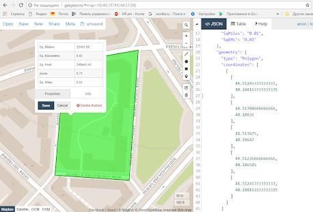
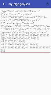
For the measurements the calculator loopbacks the first and last vertices of polygon. Then calculates the area and perimeter. After measure you can save the polygon and its outline in GeoJSON format.
Notes:
★ you can switch on the GPS-receiver of registrator only when required to register the polygon vertex
★ the app may also operate in offline mode, which has a crucial meaning for the rural area and in desert
★ you can easily visualize GeoJSON file content on the map by http://geojson.io online tool and edit it or convert into any other formats, by other tools you can also merge multiple JSON files into one file
Aplikasi ini terdiri dari 2 bagian:
• poligon GPS registrator
• luas dan keliling kalkulator
registrator mengambil poligon simpul koordinat melalui ponsel GPS-receiver dan jika sinyal GPS penyimpangan tidak keluar dari batasan pengaturan akurasi maka mendaftar simpul. Simpul berikutnya mendaftarkan ketika jarak dari titik tetap lalu juga melebihi yang ditetapkan pengguna ambang batas jarak yaitu langkah. Untuk daerah poligon pengukuran diperlukan setidaknya 3 simpul terdaftar. Aplikasi ini juga mengukur perimeter poligon. Poligon GPS registrator juga beroperasi dalam mode background.
Untuk pengukuran kalkulator loopbacks simpul pertama dan terakhir dari poligon. Kemudian menghitung luas dan keliling. Setelah ukuran Anda dapat menyimpan poligon dan garis besar nya dalam format GeoJSON.
Catatan:
★ Anda dapat beralih pada GPS-receiver dari registrator hanya bila diperlukan untuk mendaftarkan vertex poligon
★ aplikasi ini juga dapat beroperasi dalam mode offline, yang memiliki arti penting bagi daerah pedesaan dan di padang gurun
★ Anda dapat dengan mudah memvisualisasikan isi file GeoJSON pada peta dengan http://geojson.io alat online dan mengeditnya atau mengkonversi ke format lain, oleh alat-alat lain Anda juga dapat menggabungkan beberapa file JSON ke dalam satu file
First Version
9Apps 4.9


