
Thousands of top best android apps on 9Apps! 20,000+ users downloaded Land Area Calculator latest version on 9Apps for free every week! It truly does not offer any money. This hot app was released on 2018-11-15. 9Apps allows you to download more apps and updated daily!
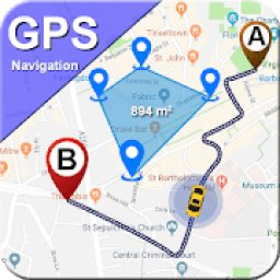
GPS Field Area Measurement is a free tool to measure area for land or distance measurement on the map with great accuracy. GPS area calculator app includes other features like displacement measurement, Land area calculator, Unit converter, GPS Compass field direction, level meter, street view, nearby places and route finder maps and navigation. Once you place the points on the map then calculate the area between all the points with remarkable accuracy. GPS area measurement app also measure the distance with quite accuracy. You can also calculate the total area of any route. Easy to use for estimate dimension of the land on the map.
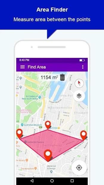
GEO area calculator alongwith optimized maps to effectively save memory space you can place multiple accurate points on the map to measure the area for field, collect ground samples or, GIS surveys. Users can choose from a variety of units including feet, meter or miles. Real-time tracking and calculate area, distance, custom path and much more between the points. If you have to find the large area like to find area of country, you can find area with few seconds.
Main Features for GEO area calculator: Street view route planner
• Tap on the map to mark area
• GPS Area has no restrictions on sharing your data
• Measure perimeter instant, estimate perimeter.
• Displacement measure on the map between the points.
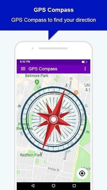
• Level Meter
• Global live street view panorama.
• Save any calculate area.
• Drag and Drop marker to place marker
• User friendly
• Unit converter
• Places around your location
• GPS Route finder
• Live ear thmap inside the gps area calculator
• Satellite view map to show 3d area buildings.
• GPS tracking measure for driving around specific boundaries.
• Driving route for car, bus and hiking tourist.
• Accurate area calculator, map measure for buildings, roads and land based surveys.
GPS area calculator for land is supported by all types of devices. Measure area or calculate distance of any place without going there. Distance and area measure live street view navigation is an interesting tool with multiple features. Some main features are highlighted below
Geo Area Measurement for Land
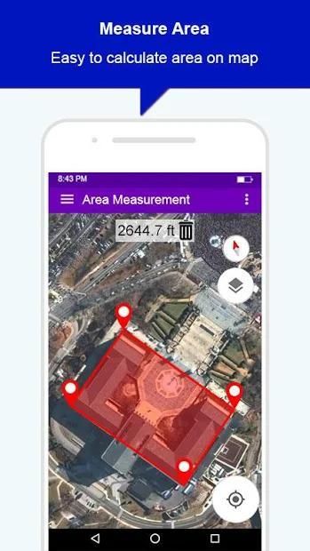
To calculate area of any place, tap on the map to mark area atleast three points. After selecting area will be calculated and displayed.
Unit Converter
You can convert the selected area into multiple units i.e feet , meter or miles
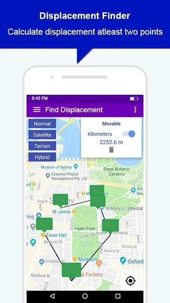
Displacement Measurement
Distance can be measured between the points, tap on map to mark points and distance is displayed.
Global Live Street View
Live street view of the place where you plan your trip . See realtime satellite view normal, terrain, street view or hybrid view. Go around in the street.
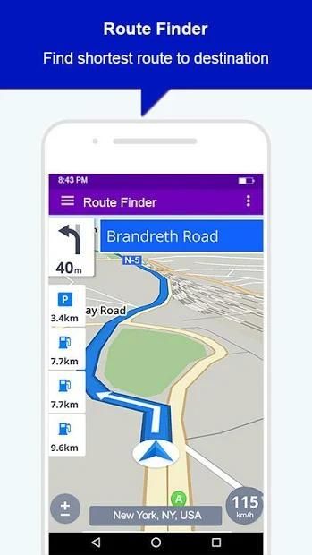
Route Finder
Find route to your desired route. Now a traveler can estimate his trip duration using route finder. It shows multiple routes to destination with different distances, each route gives ETA(Estimated time of arrival) depending on the distance and traffic along the route.
GEO AREA is for:
- Land based surveys
- Farm management for Farmers.
- Manage Land record
- Agronomists - Construction surveys
- Health, Education and facilities mapping
- Farm fencing
- Sports track measurement
- Construction sites and building sites area
- Asset mapping
- Landscape artists
- Landscape design
Pengukuran Area Lapangan GPS adalah alat gratis untuk mengukur area pengukuran tanah atau jarak di peta dengan akurasi tinggi. Aplikasi kalkulator area GPS mencakup fitur-fitur lain seperti pengukuran perpindahan, kalkulator area tanah, konverter unit, arah bidang Kompas GPS, pengukur level, tampilan jalan, tempat-tempat terdekat, dan peta pencari rute serta navigasi. Setelah Anda menempatkan titik-titik pada peta, hitung luasnya di antara semua titik dengan akurasi yang luar biasa. Aplikasi pengukuran area GPS juga mengukur jarak dengan cukup akurat. Anda juga dapat menghitung luas total rute apa pun. Mudah digunakan untuk memperkirakan dimensi tanah di peta.
GEO area calculator bersama dengan peta yang dioptimalkan untuk menghemat ruang memori secara efektif Anda dapat menempatkan beberapa titik akurat pada peta untuk mengukur area untuk lapangan, mengumpulkan sampel tanah atau, survei GIS. Pengguna dapat memilih dari berbagai unit termasuk kaki, meter atau mil. Pelacakan real-time dan menghitung luas, jarak, jalur khusus, dan banyak lagi di antara titik-titik. Jika Anda harus menemukan area yang luas seperti untuk menemukan wilayah negara, Anda dapat menemukan area dengan beberapa detik.
Fitur Utama untuk GEO area calculator: Street view perencana rute
• Ketuk pada peta untuk menandai area
• Area GPS tidak memiliki batasan untuk membagikan data Anda
• Mengukur perimeter instan, perkirakan kelilingnya.
• Ukuran perpindahan pada peta di antara titik-titik.
• Level Meter
• Panorama jalan hidup global.
• Simpan area hitung apa pun.
• Seret dan Lepas penanda untuk menempatkan penanda
• Mudah digunakan
• Pengonversi satuan
• Tempat di sekitar lokasi Anda
• pencari rute GPS
• Thmap telinga langsung di dalam kalkulator area gps
• Peta tampilan satelit untuk menampilkan bangunan daerah 3d.
• Ukuran pelacakan GPS untuk mengemudi di sekitar batas-batas tertentu.
• Mengemudi rute untuk mobil, bus, dan wisata hiking.
• Kalkulator area akurat, ukuran peta untuk bangunan, jalan dan survei berbasis lahan.
Kalkulator area GPS untuk lahan didukung oleh semua jenis perangkat. Ukur luas atau hitung jarak tempat mana pun tanpa pergi ke sana. Jarak dan area mengukur navigasi jalan jalan hidup adalah alat yang menarik dengan beberapa fitur. Beberapa fitur utama disorot di bawah ini
Pengukuran Geo Area untuk Tanah
Untuk menghitung luas suatu tempat, ketuk pada peta untuk menandai area setidaknya tiga titik. Setelah memilih area akan dihitung dan ditampilkan.
Unit Konverter
Anda dapat mengonversi area yang dipilih menjadi beberapa unit yaitu kaki, meter, atau mil
Pengukuran Pemindahan
Jarak dapat diukur antara titik-titik, ketuk pada peta untuk menandai titik dan jarak ditampilkan.
Global Live Street View
Jalan hidup melihat tempat Anda merencanakan perjalanan Anda. Lihat tampilan satelit realtime normal, medan, tampilan jalan atau tampilan hibrida. Berkeliaran di jalan.
Route Finder
Temukan rute ke rute yang Anda inginkan. Sekarang seorang pelancong dapat memperkirakan durasi perjalanannya menggunakan pencari rute. Ini menunjukkan beberapa rute ke tujuan dengan jarak yang berbeda, setiap rute memberikan ETA (Perkiraan waktu kedatangan) tergantung pada jarak dan lalu lintas di sepanjang rute.
GEO AREA adalah untuk:
- Survei berbasis darat
- Manajemen peternakan untuk Petani.
- Kelola catatan Tanah
- Agronomis - Survei konstruksi
- Pemetaan Kesehatan, Pendidikan, dan fasilitas
- Pagar pertanian
- Pengukuran lintasan olahraga
- Situs konstruksi dan area situs bangunan
- Pemetaan aset
- Seniman lansekap
- Desain lanskap
GPS Area Calculator: Street View Route Finder
9Apps 4.9


