Are you finding some interesting apps? 20,000+ users downloaded GPS Area Calculator latest version on 9Apps for free every week! You get various free apps from the store. This hot app was released on 2019-06-27. Be sure that you check your current app before you start a run.
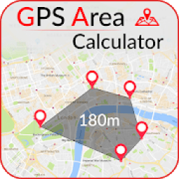
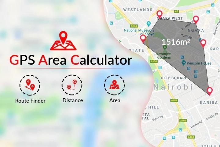
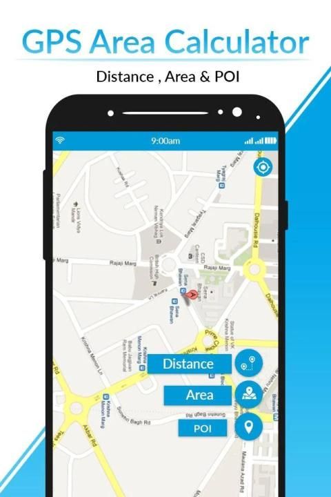
GPS area calculator is a perfect tool for measuring areas, distance on the map.
You are placing your points on the map and then calculating the region between all these points. You can calculate the complete land area of any path with the field area measurement app. Land Area Measurement is a helpful application for the accurate calculation of GPS area or GPS distance.
Land area measurement app is helpful for land area calculation for all forms and plot sizes such as triangles, rectangles, or simple polygons. Just tap the map and calculate the region of the property, the distance in separate units and the measurements.
Especially if you need to calculate a bigger area like the area of city or country, you can easily calculate area by using this app. Paddock measurement is very easy now, this planimeter is best option to measure all type of land like constructed or unconstructed, agriculture fields, forests, rivers, dams, sea, mountains. This app shows the view of land directly forms satellite.
GPS Digital Compass Navigation is a Real Compass. GPS Digital compass has a device’s real-time Longitude and Latitude Finder App. It shows magnetic fields, using Google map and GPS navigation’s Satellite Maps.
❁❁...App Features:...❁❁
✦ GPS Area Measurement Calculator helps as Distance and Area measurement app
✦ Tap on the map and calculate the area
✦ Easy for map field measurement
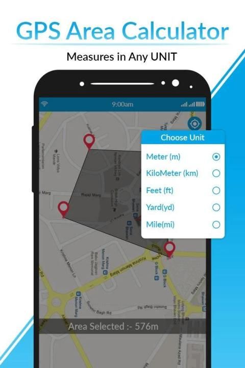
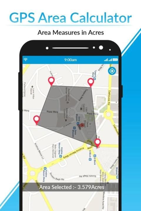
✦ Customize the unit of GPS Area
✦ Choose from the units as square feet, meters, inches, etc
✦ Just a single tap to erase the current measurement and calculate a new one
✦ You may select three, four or more points to calculate the GPS Area
✦ You can save the points in the history of GPS Area or the distance calculated.
❁❁...You Can Use GPS Area Calculator-Field Measurement App for:
...❁❁
❖ Health, Education, and facilities mapping
❖ Farm fencing
❖ Agronomists
❖ Town planners
❖ Construction surveyor
❖ Landscape design
❖ Sports track measurement
❖ Land-based surveys
❖ Farmers, for farm management
❖ Land record management Construction sites and building sites area
❖ Assets mapping
❖ Landscape artists
❖ Construction surveys
❁❁..How to use..❁❁
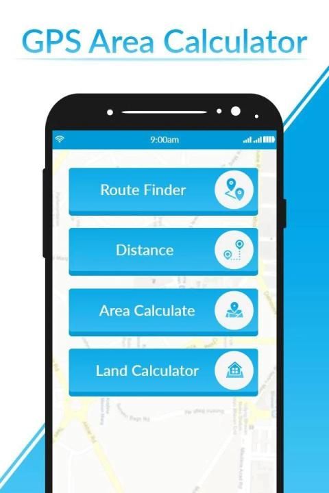
1) Area Measurement
You must mark at least three points to calculate the area on the map. Once an area is selected, it will be calculated and displayed. The selected area can be converted to multiple units. You can also save the measured area of your GPS areas.
This application is very useful for Land Surveys.
2) Distance Measurement
You must mark at least two points to calculate distance on the map. Once the distance is selected, it will be calculated and displayed.
3.) compass
A compass is an instrument used for navigation and orientation that shows direction relative to the geographic North. Geographic North is computed given the magnetic North and the magnetic declination at your current location. Find and keep track of the right heading. Get information about your current position or a target position. Simple to use, use it like a real compass.
Gps Compass map instructions is an intelligent free compass with the recent map and GPS navigation to make it easier to explore the map.
You have no need to go to the site to measure land. Just open this Gps Area calculator app in your mobile, this app will do fieldwork for you. This app is very helpful for construction planning. This app show detail terrain of land and building on the land from satellite camera. Satellite camera shows a live view of the land. Gps Area Calculator has no limits, you may calculate the area of countries and continents within a few seconds.
Thank You .....................!!!!
Kalkulator area GPS adalah alat yang sempurna untuk mengukur area, jarak pada peta.
Anda menempatkan titik Anda di peta dan kemudian menghitung wilayah di antara semua titik ini. Anda dapat menghitung luas lahan lengkap jalur apa pun dengan aplikasi pengukuran luas bidang. Pengukuran Area Tanah adalah aplikasi yang bermanfaat untuk perhitungan akurat area GPS atau jarak GPS.
Aplikasi pengukuran luas tanah sangat membantu untuk perhitungan luas lahan untuk semua bentuk dan ukuran plot seperti segitiga, persegi panjang, atau poligon sederhana. Cukup ketuk peta dan hitung wilayah properti, jarak dalam unit yang terpisah, dan pengukuran.
Terutama jika Anda perlu menghitung area yang lebih besar seperti area kota atau negara, Anda dapat dengan mudah menghitung area dengan menggunakan aplikasi ini. Pengukuran Paddock sangat mudah sekarang, planimeter ini adalah pilihan terbaik untuk mengukur semua jenis tanah seperti dibangun atau tidak, bidang pertanian, hutan, sungai, bendungan, laut, gunung. Aplikasi ini menunjukkan pemandangan daratan langsung dari satelit.
Navigasi Kompas Digital GPS adalah Kompas Nyata. GPS Digital kompas memiliki Aplikasi Bujur dan Latitude Finder real-time perangkat. Ini menunjukkan medan magnet, menggunakan peta Google dan Peta Satelit navigasi GPS.
❁❁ ... Fitur Aplikasi: ... ❁❁
✦ Kalkulator Pengukuran Area GPS membantu sebagai aplikasi Pengukuran Jarak dan Area
✦ Ketuk pada peta dan hitung area
✦ Mudah untuk pengukuran bidang peta
✦ Sesuaikan unit Area GPS
✦ Pilih dari satuan sebagai kaki persegi, meter, inci, dll
✦ Hanya satu ketukan untuk menghapus pengukuran saat ini dan menghitung yang baru
✦ Anda dapat memilih tiga, empat poin atau lebih untuk menghitung Area GPS
✦ Anda dapat menyimpan titik dalam sejarah Area GPS atau jarak yang dihitung.
❁❁ ... Anda Dapat Menggunakan Aplikasi Pengukuran Kalkulator Area GPS untuk:
... ❁❁
Mapping Pemetaan kesehatan, pendidikan, dan fasilitas
❖ Pagar pertanian
❖ Ahli agronomi
❖ Perencana kota
❖ Surveyor konstruksi
❖ Desain lansekap
❖ Pengukuran lintasan olahraga
❖ Survei berbasis lahan
❖ Petani, untuk manajemen pertanian
❖ Pengelolaan catatan pertanahan Situs konstruksi dan area situs bangunan
Mapping Pemetaan aset
❖ Seniman pemandangan
❖ Survei konstruksi
❁❁..Cara menggunakan..❁❁
1) Pengukuran Area
Anda harus menandai setidaknya tiga titik untuk menghitung area pada peta. Setelah area dipilih, itu akan dihitung dan ditampilkan. Area yang dipilih dapat dikonversi menjadi beberapa unit. Anda juga dapat menyimpan area yang diukur dari area GPS Anda.
Aplikasi ini sangat berguna untuk Survei Tanah.
2) Pengukuran Jarak
Anda harus menandai setidaknya dua titik untuk menghitung jarak di peta. Setelah jarak dipilih, itu akan dihitung dan ditampilkan.
3.) kompas
Kompas adalah instrumen yang digunakan untuk navigasi dan orientasi yang menunjukkan arah relatif ke Utara geografis. Geografis Utara dihitung dengan mengingat Utara magnetik dan deklinasi magnetik di lokasi Anda saat ini. Temukan dan lacak tajuk yang benar. Dapatkan informasi tentang posisi Anda saat ini atau posisi target. Mudah digunakan, gunakan seperti kompas nyata.
Instruksi peta Kompas Gps adalah kompas gratis cerdas dengan peta terbaru dan navigasi GPS untuk mempermudah menjelajahi peta.
Anda tidak perlu pergi ke situs untuk mengukur tanah. Cukup buka aplikasi kalkulator Area Gps ini di ponsel Anda, aplikasi ini akan melakukan kerja lapangan untuk Anda. Aplikasi ini sangat membantu untuk perencanaan konstruksi. Aplikasi ini menunjukkan detail medan tanah dan bangunan di darat dari kamera satelit. Kamera satelit menunjukkan pemandangan langsung ke daratan. Kalkulator Area Gps tidak memiliki batas, Anda dapat menghitung luas negara dan benua dalam beberapa detik.
Terima kasih ..................... !!!!


9Apps 4.9


