

We access you a main official website for app download. 20,000+ users downloaded GPS Polygon Area latest version on 9Apps for free every week! All its functions are there and updated. This hot app was released on 2018-07-21. Just use it when absolutely necessary.
The app consist from 2 parts:
• polygon GPS registrator
• area and perimeter calculator
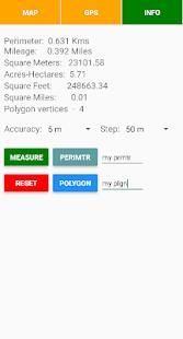
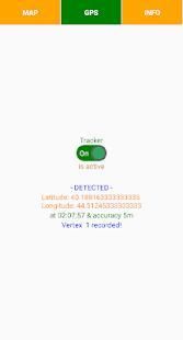
The registrator takes a polygon vertices coordinates through the mobile GPS-receiver and if GPS signal deviation is not out of accuracy setup restriction then it registering a vertex. The next vertex is registering when the distance from the last fixed vertex also exceeding the user defined distance threshold i.e. step. For the polygon area measurement required at least 3 registered vertices. The app also measures the polygon perimeter. The polygon GPS registrator is also operating in background mode.
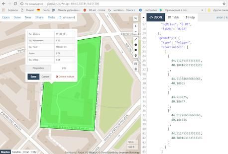
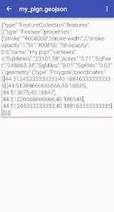
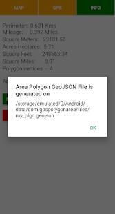
For the measurements the calculator loopbacks the first and last vertices of polygon. Then calculates the area and perimeter. After measure you can save the polygon and its outline in GeoJSON format.
Notes:
★ you can switch on the GPS-receiver of registrator only when required to register the polygon vertex
★ the app may also operate in offline mode, which has a crucial meaning for the rural area and in desert
★ you can easily visualize GeoJSON file content on the map by http://geojson.io online tool and edit it or convert into any other formats, by other tools you can also merge multiple JSON files into one file
एप्लिकेशन 2 भागों से मिलकर बनता है:
• बहुभुज जीपीएस registrator
• क्षेत्र और परिधि कैलकुलेटर
registrator एक बहुभुज कोने मोबाइल जीपीएस रिसीवर के माध्यम से समन्वय करता है और यह एक शीर्ष पंजीकरण के GPS सिग्नल के विचलन सटीकता सेटअप प्रतिबंधों से बाहर तो नहीं है लेता है। अगले शिखर दर्ज की है जब पिछले तय शिखर से दूरी भी उपयोगकर्ता परिभाषित दूरी सीमा अर्थात कदम से अधिक। बहुभुज क्षेत्र के लिए माप की आवश्यकता कम से कम 3 पंजीकृत कोने। एप्लिकेशन भी बहुभुज परिधि को मापता है। बहुभुज जीपीएस registrator भी पृष्ठभूमि मोड में काम कर रहा है।
मापन के लिए कैलकुलेटर बहुभुज की पहली और आखिरी कोने लूपबैक। तब क्षेत्र और परिधि गणना करता है। उपाय के बाद आप बहुभुज और GeoJSON प्रारूप में इसकी रूपरेखा बचा सकता है।
टिप्पणियाँ:
★ आप केवल जब बहुभुज शिखर रजिस्टर करने के लिए आवश्यक registrator की जीपीएस रिसीवर पर स्विच कर सकते हैं
★ एप्लिकेशन भी ऑफलाइन मोड है, जो ग्रामीण क्षेत्र के लिए और रेगिस्तान में एक महत्वपूर्ण अर्थ नहीं है में काम कर सकते हैं
★ आप आसानी से http://geojson.io ऑनलाइन उपकरण के द्वारा नक्शे पर GeoJSON फ़ाइल सामग्री कल्पना और इसे संपादित या किसी अन्य प्रारूपों में कनवर्ट करते हैं, अन्य उपकरणों से कर सकते हैं आप भी एक फ़ाइल में एकाधिक JSON फ़ाइलें विलय कर सकते हैं
First Version
9Apps 4.9


